Vegetation Index
Vegetation Index


The land surface is generally differentiated by using vegetation indices. The vegetation indices are arithmetic combinations of surface reflectance at two or more different spectral bands. There are various types of Vegetation indices: NDVI(Normalised Difference Vegetation Index), NDBI (Normalised Difference Build-Up Index), and BU (Build-Up Index). They are used for different purposes in spatial analyses. There are various Vegetation indices, but the most widely used vegetation index is NDVI (Normalised Difference Vegetation Index).
Remote sensing data[1] is used to derive Vegetation indices and are related to several variables quantifying vegetation indices and states. Vegetation indices are widely used to analyze land cover changes and monitor trends. This factor is used to identify the state of vegetation, canopy attributes, proportion of photosynthetically active radiation absorbed by the canopy, leaf pigments, and vegetation-free areas.
The numerical values of NDVI vary between -1 and 1. Positive numerical values show dense vegetation and from 0 to -1 shows wet, non-vegetated areas and water bodies.
- NDVI range from -1 to 0 represents water bodies
- NDVI range from 0.1 or less represents areas of barren rocks and sand or snow
- NDVI range from 0.2 to 0.5 represents shrubs and grasslands or senescing crops
- NDVI = 0.6 to 1.0 represent dense vegetation or tropical rainforest
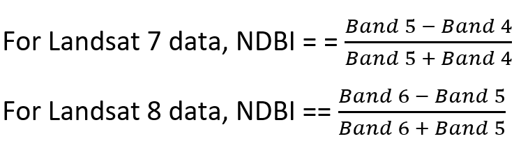
The mathematical formula to calculate NDVI, NDBI, and BU.


NIR stands for Near-Infrared and Red is Wavelength/ Micrometer.
The selection of NIR and Red is different for different satellite(Landsat) data.
For Landsat 7 data,

For Landsat 8 data,
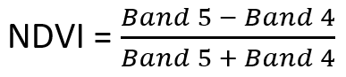
Band 4 in landsat7 and Band 5 in Landsat 8 represent NIR, and Band 3 in Landsat 7 and Band 4 in Landsat 8 represent Red.
NDBI (Normalize Difference Build-up Index) is used to emphasize build-up areas. Its value lies between -1 to +1. A negative value of NDBI represents water bodies, whereas the higher value represents build-up areas. NDBI value for vegetation is low.
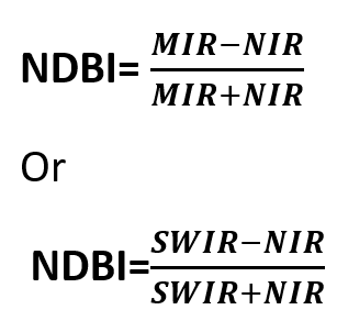
MIR stands for Middle Infrared Wavelength/Micrometer, and SWIR stands for Short wavelength/Micrometer.
Again the selection of SWIR and NIR is different for different satellite (Landsat) data.
BU = NDBI – NDVI
Where BU is a build-up index used to analyze Urban patterns using NDBI and NDVI, a built-up index is a binary image with only a higher positive value that indicates built-up and barren.
This is Remote sensing(Landsat 8, march 2015) with band 4 data in TIF formate with the area of interest Delhi.

This is Landsat 8 march 2015, band 5 data with the same area of interest Delhi.

The indices of the above data lie between -0.0927, which is the lowest, and 0.6046, which is the highest.
[1]J.M. Chen, in Comprehensive Remote Sensing, 2018


